Maimed by Thirst – Atef Saad, Rossella Altobelli
Instrumentalized violence in the contested palestinian territory
di: Atef Saad, Rossella Altobelli

di: Atef Saad, Rossella Altobelli
In its purest form, water becomes, provides for and sustains life; in its most corrupt and distorted conception, it shapeshifts into instrumentalized violence. Water has traveled from one extreme to the other, facilitating a greater process of territorial fragmentation, within the contested palestinian territory. Investigating the uses and allocation of water throughout the history of coexistence and eventual contestation, draws a new point of view in understanding the plummeting Israeli-Palestinian conflict.
Such history of coexistence began in the last decades of the XIX century, when an increasing number of Jewish people moved to the region by waves of “Aliyah”, a term referring to the specific “return-migration” phenomenon of the Jewish community dispersed in the world and based on the ideological proposal of the Zionist movement (Gurevich D., Gertz A., Bachi R., The Jewish Population of Palestine: Immigration, Demographic Structure and Natural Growth, Jerusalem, Jewish Agency for Palestine, 1944). Following World War I, Britain was granted a mandate to govern Palestine (1914-1948), where a population of around 689.000 people was living (94.000 Jewish, 525.000 Arabs, 70.000 Christians in 1914 according to the estimations by Sergio della Pergola and based on the work of Roberto Bachi at the Israel Central Bureau of Statistics (“Demography in Israel/Palestine: Trends, Prospects, Policy Implications”, 2001).
During this period, to escape antisemitic persecution in Europe and through other aliyah waves, hundreds of thousands of Jewish immigrants relocated to the region inhabited by both a Palestinian population and a growing Jewish community: while the Muslim and Christian population doubled (from 595.000 to 1.324.000), the Jewish population grew almost sevenfold (from 94.000 to 630.000 – see della Pergola’s estimations in 2001). The initial settling of Jewry within Palestine followed the basilar principle set by Zionist ideologies: the new Jewish identity, in seeking to build a homeland for the Jewish people, based itself on the cultivation of land, reviving the ancient Jewish way of life. Such ideology spatialized into the first Jewish settlements, whose establishment, growth and continued existence relied on agricultural activity.
It is through agriculture that the demographic narrative intertwines with the matter of water: the land which the Jewish sought to nurture was semi-arid, hostile to most crops and a challenge to the timid farming knowledge possessed. To cope with such a thirsty land, the Jewish spent most of their funding towards the modernization of agriculture technologies. In the 1930s, Jewish immigration to Palestine saw a dramatic surge, prompting the indigenous Palestinian population to exert pressure on the British authorities to regulate the influx of immigrants. However, due to the escalating persecution of Jews in Europe, many were unwilling to endure lengthy waits for immigration certificates, therefore turning to unregistered immigration by sea. By the outset of World War II, tens of thousands of Jews had settled in Palestine. This rapid increase in the population placed immense strain on resources, with water scarcity emerging as a particularly critical challenge.
After Israel’s establishment in 1948 and the removal of British restrictions on land and water use, the number of cultivated lands rose by 150%, sustained by a substantial increase in irrigated plots (Tal Alon, “To Make a Desert Bloom: The Israeli Agricultural Adventure and the Quest for Sustainability”, 2007). Indeed the new Jewish State allocated a large share of its budget to the development of water technology and water infrastructure, leading to improvements in groundwater pumping and the construction of the National Water Carrier respectively. Planned by the water company Mekorot, the NWC is a system of pipelines connecting the Sea of Galilee to the arid Negev Desert.
Its one hundred thirty kilometers were planned to provide for domestic supply and irrigation throughout the western plains of the territory, which develop far from natural groundwater sources, and southern plains of the territory, where the groundwater provided by the coastal aquifer did not meet the amount of water required by the inhabiting population. Such an artificial diversion of superficial water diminishes the natural flow from the Sea of Galilee throughout the Jordan River Basin, a water source shared with the neighboring states of Lebanon, Syria and Jordan, ultimately affecting their share of the basin’s water yield.
The intervention also disrupted the basin’s ecology, the largest consequence having been a gradual shrinkage of the Jordan river and Dead Sea lake. The National Water Carrier successfully began operating in the early 1960s. It is with such a relevant commission that Mekorot was made Israel’s national water company; its ambition of creating a uniform water enterprise had existed since the early 1930s and has since then been developing a borderless water infrastructure throughout the territory. By 1982, the company had officially acquired all of the West Bank water supply systems, gaining full control of its distribution within Palestinian communities. This translates into a prioritization in the allocation of the available water resources for the Israeli communities on the one hand, restriction of access, targeted water shortages and water outages for the Palestinian communities on the other (United Nations High Commissioner for Human Rights, “The allocation of water resources in the Occupied Palestinian Territory, including East Jerusalem”, 2021).
At the conclusion of the Six-Day War, Israel had successfully captured the West Bank, including East Jerusalem, and redrew its borders around the idea of “The Greater Israel ” (Eretz Yisrael Ha-Shlema). These new boundaries laid the foundation for the construction of the West bank barrier, which has been intended by Israel as a necessary security device against the terrorist attacks from the West Bank, whereas Palestinians define it as a representation of racial segregation and the Israeli apartheid regime.
While 15% of the wall is built on Israeli territory, 85% of the barrier is on Palestinian territory, developing within the internationally recognized Green Line up to 18 km away from the border, resulting not only in cutting off land and resources but also significant control over vital water resources (UN Office for the Coordination of Humanitarian Affairs, “Barrier Update: Special Focus”, 2011). Strategically, the wall was constructed from the northern regions, effectively severing Palestinian access to the Mountain Aquifer (OCHA, “The humanitarian impact on Palestinians of Israeli settlements and other infrastructure in the west bank”, 2007).
This development drastically altered the allocation of water in the territory, as the underlying Western Groundwater Basin is the highest yielding aquifer, with a substantial portion of it now trapped between the wall and the Green Line. As a result, Israel secured control over an additional one-third of the most important water source within the region, regulating Palestinian communities’ access to water through the Water Agreement stated in Oslo and on the basis of an economic exchange (State of Israel – Water Authority, “The Issue of Water between Israel and the Palestinians”, 2009; European Parliamentary Research Service, “Water in the Israeli-Palestinian conflict”, 2016). While the 1947 Partition Plan was enabling the West Bank to keep an access to the main water resource of its territory, the Green Line and the barrier prevent this territory the same access, then partially regulated by the Oslo agreement, de facto depriving the West Bank of a resource it owned that only a few years earlier was under its full jurisdiction.
The occupation of the West Bank also meant characterizing its territory in three different areas of control, notoriously known as areas A, B and C, with territorial control being the highest in Area C. The latter constitutes around sixty percent of the West Bank and comprises the most productive locations for drilling wells and facilities for water acquisition and treatment. Particularly, such an area extends throughout the entire contact line of the West Bank and the Jordan river, where Palestine had developed its highest agricultural activity. Such restrictive measures were not imposed in Gaza, where the only water source available to the inhabiting Palestinian population is the coastal aquifer, shared with the southern Israeli region.
According to an Amnesty International report, “due to the aquifer’s east to west flow, the quantity of water extracted in Gaza does not diminish the available yield in Israel. (…) However, extraction by Israel from this aquifer in the area to the east of Gaza affects the supply available to be extracted in Gaza”; nevertheless, the same report mentions that accessing reliable data is not possible at the moment. It is however factual that the population of Gaza has overrun the sustainable capacity of the aquifer in hope of matching the water needs of a population of over two million. Such over extraction has damaged the aquifer which is now infiltrated by sewage and sea water. Water may not travel from the West Bank to Gaza, and since the blockade of 2005, no supplies or materials needed for the construction of water treatment plants may enter the landlocked strip (OCHA, “Call for an immediate opening of Gaza’s crossings”, 2009).
The World Health Organization suggests a total of one hundred liters of water per capita, per day. Israel grants its population a total of three hundred liters per capita, per day. On average, Palestinians in the West Bank have access to seventy liters of water per capita, per day, with numbers reaching as low as ten liters (Amnesty International, “troubled waters – Palestinians denied fair access to water”, 2009). In Gaza, Palestinians have access to a sufficient amount of water, however ninety seven percent of that water is unfit for human consumption according to WHO guidelines due to salt infiltration and sewage contamination.
Such an unequal allocation of water is a result of the process of the water infrastructuring of the territory run by Israel’s urbanization. If ‘to maim’ is to severely injure a living being causing certain parts of its body to be irreversibly dysfunctional, creating a state of being oscillating between life and death, a territory can be maimed by thirst when its potential to offer water through the over extraction of its resources is weakened beyond its sustainable capabilities and through the manipulation of its natural flows.
A territory can be maimed by thirst when its connections are restricted and over complicated through the imposition of fixed as well as flying checkpoints, physical borders as drastic as nine-meter-high walls and as tedious as concrete roadblocks, ultimately delaying the time needed for water to reach the neediest of communities. A territory can be maimed by thirst through strategic warfare, targeting water infrastructure through bombardments, systemic damaging of water lines and perforation of water cisterns (B’Tselem – The Israeli Information Center for Human Rights in the Occupied Territories, “Israel pours concrete into well and destroys irrigation system in the Palestinian village of al-Hijrah, south of Hebron”, last accessed on 27.10.2023).
The current escalation in violence is tragically claiming the lives of thousands of civilians. What should be noticed, however, is that hydropolitical processes have a dramatic impact on people’s lives and on the generation of violence: the situation in Gaza is particularly dire, as the population of the strip is faced with a profound impairment of life, which the Israeli and Egyptian blockade have aggravated by reducing access to water. It is certainly no coincidence that one of Israel’s first response actions to the terrible terrorist attacks of October 7 was the blocking of water. If on the one hand urbanization and water infrastructure has enabled profound development and prosperity of the Israeli territory, on the other hand the spatial forms of water sovereignty over the area generate both a form of mutilation of people’s lives (it is no coincidence that it is often referred to as a violation of human rights by the UN) and a spatial weapon of annihilation, based on the torment of thirst.
* “Era il marzo del 2003, quando Bush e Blair, appoggiati da numerosi governi, hanno dichiarato guerra preventiva all’Iraq. La circostanza mi ha procurato un turbamento profondo. Tutte le malformazioni culturali ereditate dal passato venivano al pettine: il concetto stesso di guerra preventiva faceva sorgere l’impellente necessità di contrapporre l’idea di Pace Preventiva. Nella storia la pace è sempre venuta a seguito di una guerra ed è stata considerata come suo risultato, dunque guerra nascosta sotto la maschera della pace e pace costituita di mera apparenza. Ho capito in quel momento che io stesso, nonostante l’impegno artistico, intellettuale e pratico, indirizzato verso una trasformazione responsabile della società, dovevo fare un ulteriore passo, ancor più deciso ed efficace, per contribuire al cambiamento di questa umanità. È così che nasce il segno del Terzo Paradiso”.
“It was March 2003, when Bush and Blair, supported by numerous governments, declared preventive war on Iraq. The circumstance caused me a profound disturbance. All the cultural malformations inherited from the past came to a head: the very concept of preventive war gave rise to the urgent need to counteract the idea of Preventive Peace. In history, peace has always come following a war and has been considered as its result, therefore war hidden under the mask of peace and peace constituted by mere appearance. I understood in that moment that I myself, despite my artistic, intellectual and practical commitment, directed towards a responsible transformation of society, had to take a further step, even more decisive and effective, to contribute to the change of this humanity. This is how the sign of the Third Paradise was born.” Michelangelo Pistoletto, La Pace Preventiva, 2023.
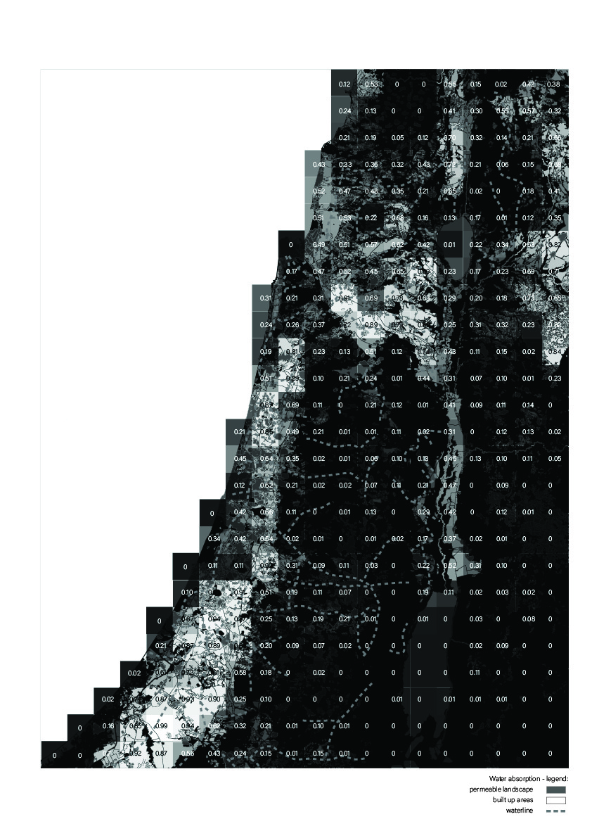
Figure 1:
The absence of water is represented through a metaphor in which the territory becomes a human body. As such, when deprived of water, the territory will manifest the bodily symptoms of thirst: dryness of skin, muscle pain, disorientation and severe headaches. Cartographies are thus graphically manipulated to evoke the sensations brought by these symptoms.
The image corresponds to a cartographic analysis of the absorption potential of the territory, simulating the symptom of dryness through pixelation. By superimposing a grid onto a map of the State of Israel, the West Bank and Gaza, a number of parcels have been defined. Each parcel is marked by a number and plotted with a given transparency, both representing the ratio of permeable land over the total land contained within that parcel. The lower the ratio, the dryer the land. In addition, drawn over the pixels and marked with a dashed gray line, is the Mekorot water network. What ultimately emerges from the analysis is the correlation between the supply of water and the land able to make use of it.
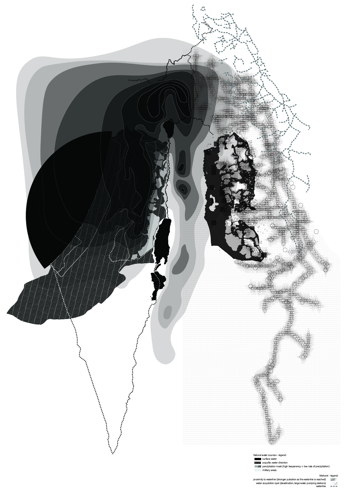
Figure 2:
On the right hand side of the image are the natural water resources available to both the State of Israel, the West Bank and Gaza. Water may be extracted from superficial and groundwater transboundary reservoirs, but may also be obtained through the collection of rainwater. The most important superficial water source is the Jordan River and its basin, which stems along the entire international border to the east of the territory, thus supplying water also to the neighboring countries of Jordan, Lebanon, Syria and Egypt. However, the territory’s highest water potential is found within its mountain aquifer (Oslo Accords, The Israeli Palestinian Interim Agreement on the West Bank and Gaza Strip, Article 40, Schedule 10, 1993) and is shared by Israel and the West Bank. The coastal aquifer has a much lower yield and is shared by the State of Israel and Gaza. On the left hand side of the drawing is a mirrored representation of the drawing. It is evoking the symptom of muscle pain through circular pulsations. A layer of circles is superimposed to the territory: the circles begin to pulsate and multiply in proximity to the Mekorot water line, highlighting the dependencies from the water network.
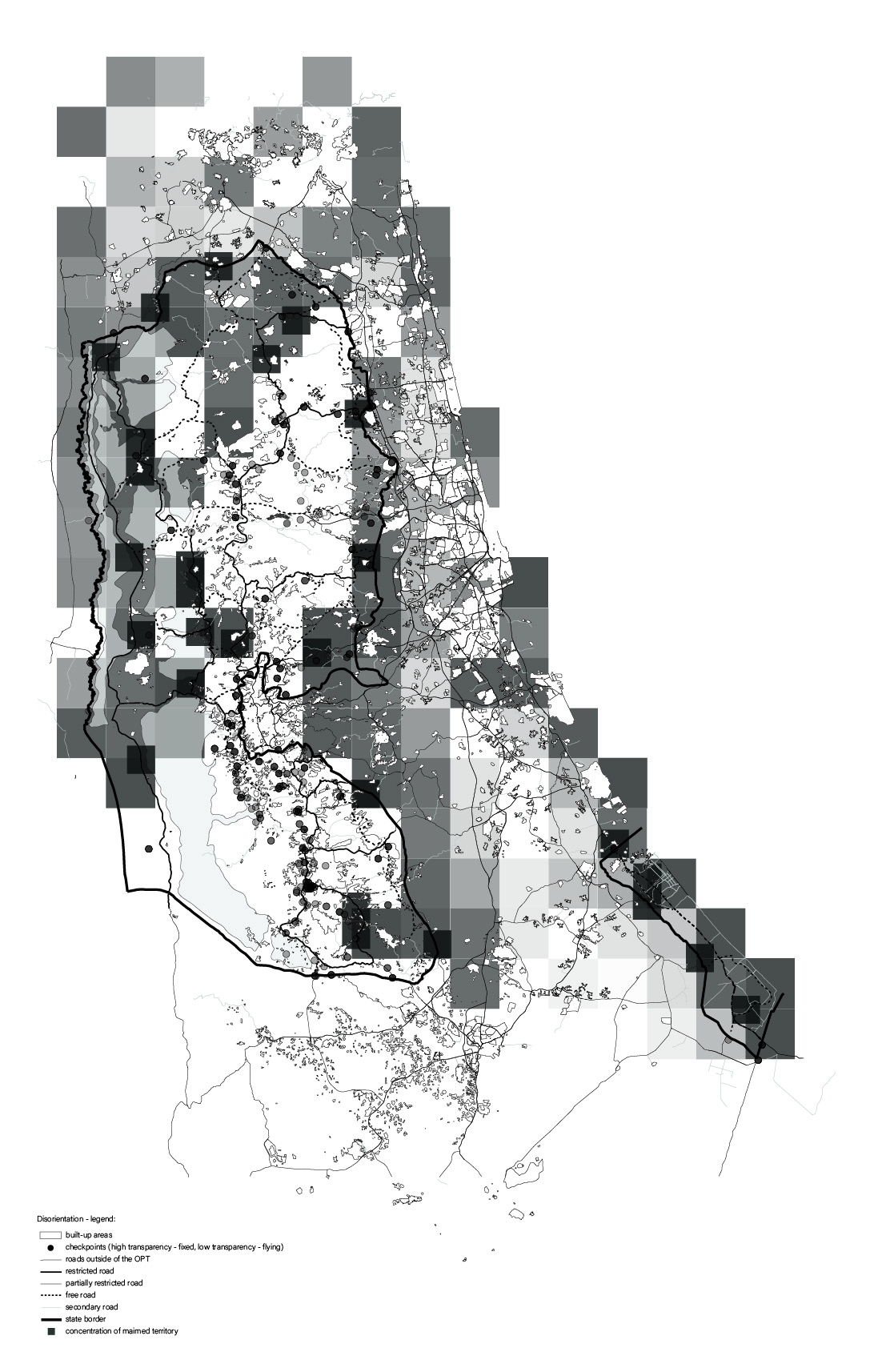
Figure 3:
Movement and access directly affects water acquisition, distribution and allocation. Cities and towns isolated from the water network must rely on tankers for their supply of water. Borders, road closures, flying checkpoints and temporary obstructions such as roadblocks continuously deviate and delay, and at times entirely denying, the arrival of water to these localities. Plotted throughout the West Bank and Gaza are checkpoints and their time spans, roads and their level of restriction, borders, all superimposed by the pixelation from the previous analysis, overcharging the final output of the drawing and simulating a sense of disorientation. Marked in smaller, darker parcels are areas of the territory in which all of the examined parameters creating thirst concentrate.
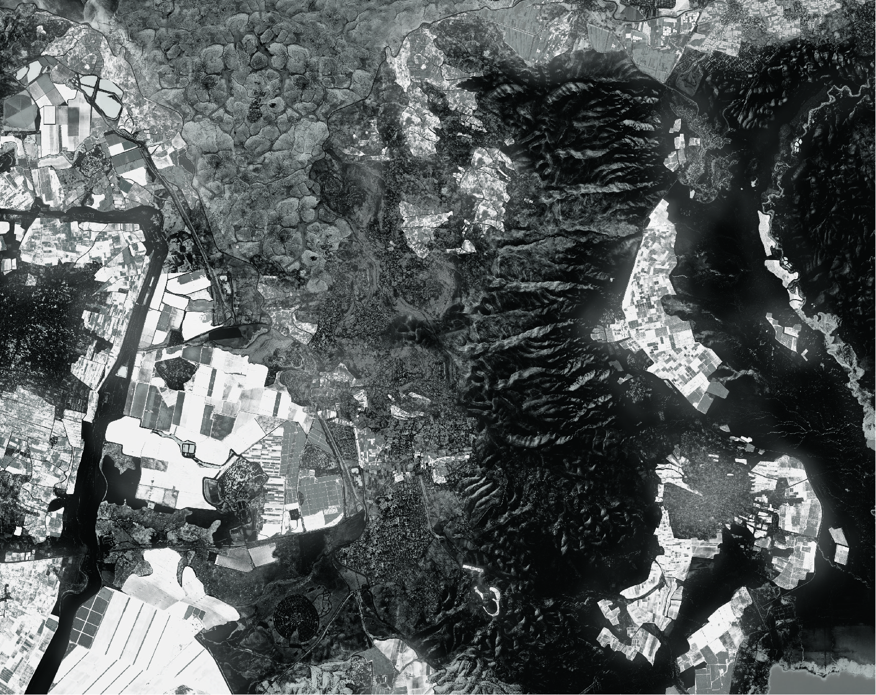
Figure 4:
The satellite image is depicting a territory which does not exist: it is an artificial compilation of spaces emerged from the territorial analysis, identified as critical concentrations of the parameters used to plot the absence of water. This was done to study possible correlations and to identify areas of intervention. A recurring feature is the presence of agricultural activity, with its spatial outputs highlighted throughout the satellite image. Graphically, this translated into the creation of a medical x-ray, reinforced by the territory-becomes-body metaphor. Such a map may eventually provide a guideline for inhabiting the violence of an imposed thirst.
Pubblicato il: 31.10.2023